A Persian shield at the Hawaii Tropical Botanical Garden on the Big Island of Hawaii.
It should come as no surprise that the Hawaii Tropical Botanical Garden houses an incredibly diverse display of plants. More than 2,000 species, according to its website. The different shapes, sizes and colors are astonishing. The Persian shield was striking for its brilliant purple color as well as the intricate details on its leaves. The garden is less than 10 miles north of Hilo on Hawaii’s Big Island and is a great alternative to sitting on another beach.
The massive face of Bonneville Mountain guards one side of Aneroid Lake.
I’m not the hiker I used to be. That was clear to me even before I set out on an overnight trip into the Eagle Cap Wilderness.
For one thing, circumstances allowed me to start my trek at the well-named Tenderfoot Trailhead, at 6,500 feet elevation, cutting out about 2,000 feet of uphill slog. A slog I used to relish. Secondly, I chose to bring along hiking poles, which I’d never used before. But I hadn’t carried that much weight for a couple years, and I figured they’d be helpful for any stream crossings. And what a funny decision that turned out to be.
With my family staying in cabins at Wallowa Lake, I could be dropped off for a through hike instead of an out-and-back. It’s always nice to be able to cover more ground in the same amount of time. My goal was to reach Bonny Lakes or Dollar Lake and camp for the night, then head down to Aneroid Lake and pop out at the Wallowa Lake Trailhead. The hike would total 14 miles, none of which I had seen previously.
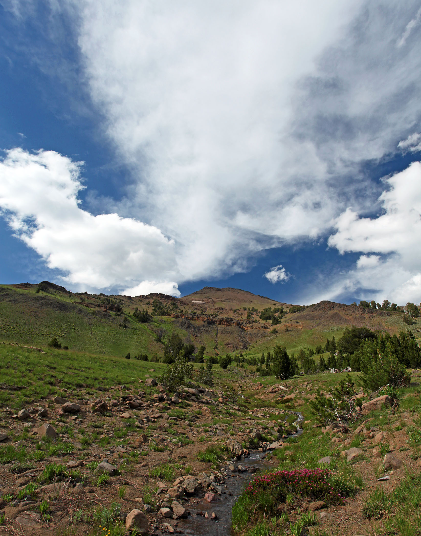
The Tenderfoot Trailhead is 6,500 feet above sea level.
On our way back toward Joseph from the Hells Canyon Overlook, we took the short detour to the Tenderfoot Trailhead, on the east edge of the Eagle Cap Wilderness. I knew that Forest Road 100 would climb three miles before ending at the trailhead; I didn’t know how bumpy and narrow it would be, with trees and bushes making friends with both sides of the car. You have to look closely just to find the turnoff. It was slow-going, but there was no cliff-hanging. On summer weekends, it’s difficult to find a parking spot at the Wallowa Lake Trailhead. Same with Two Pan Trailhead. On this Monday, there was a single car parked at Tenderfoot. Maybe that’s why the Forest Service doesn’t require a pass to park there.
After detailing my plans and projected arrival time, I was left with my backpack, my poles, the car, a trail post and a vast alpine expanse. I filled out the wilderness permit, attached a copy to my pack, grabbed my poles and charged forward. Then, after 500 feet, I stopped at Big Sheep Creek. Now, Big Sheep Creek isn’t exactly big. At it’s deepest, my calves would have gotten wet. But I didn’t feel like soaking my socks with many miles still ahead of me. Fortunately, a log bridged the creek to the other side, and I surmised that this log could easily carry my weight. Still, when you step on a log with 30 to 40 pounds on your back and $3,500 of camera gear around your neck, there’s some trepidation. Particularly if you’re a bit of a klutz. But the poles. I HAD THE POLES!
So I hoisted myself up on the log, treading lightly, balancing myself. The log was high enough that my poles couldn’t reach the bottom of the creek, so I leaned on a couple smaller branches that paralleled the log. About halfway across, one pole drifted between the log and a branch, and when I pulled up for my next step, the bottom leg of the pole popped off and began tumbling downstream. I watched hopelessly from the log. There would be no retrieving it. So, 500 feet in, I was down to one and a half poles. Off to a great start. Apparently, I hadn’t tightened the pole enough. But I managed to stay dry.
I couldn’t stay annoyed for long, as blue, purple, red, white and yellow flowers dotted the green meadows patched along the path. The creek cross-crossed the trail a few more times, and I just plowed through one, choosing wet shoes over balancing on a narrow log. Whitebark pines topped the ridge, standing out against the brilliant blue sky. Blocks of columnar basalt jutted out of a few locations in the forest.
Aneroid Mountain looms beyond Lower Bonny Lake.
Four miles in, I emerged from the trees to find Lower Bonny Lake, unveiling mountain ridges to both the left and right. Flowers of yellow and purple lined the shore, with Aneroid and Dollar mountains reflecting in the shallow pool. Aside from the mosquitoes, Lower Bonny Lake made an ideal place to spend an afternoon and evening, but it was too early to stop and would have left a long way to go the following morning.
Dollar Lake sits just off the trail near Dollar Pass at about 8,500-foot elevation.
I set my sights on Dollar Lake, and promptly passed Upper Bonny Lake without even realizing it. Turns out that “upper” is an apt description, as it sits on a small plateau above the trail. I finally saw it when looking behind me a mile and a half later as I climbed toward Dollar Pass. At the 8,400-foot ridge, the view forward included bowl-shaped Petes Point and the massive wall of Bonneville Mountain. It also included, six miles in, my first look at another person — a couple and their dog greeted me at Dollar Pass and pointed me toward Dollar Lake, a quarter-mile off the trail.
Reunited with solitude, I relaxed and ate a sandwich at Dollar Lake. With a snowy ridge as a backdrop, I thought I could just as easily be in Iceland. It felt like another good place to camp, but, being at the top of a ridge, there was a lot of wind. There also was a chance of thunderstorms that night, and I didn’t want to be at a high point if there was lightning. Somewhat regrettably, I hoisted my pack back on and started the descent to Aneroid Lake. I didn’t want to camp there, but I figured it would be the best place to be if a storm rolled in. Getting there before sunset would also cut down on my hike out in the morning.
Turns out, it’s a pretty steep drop from Dollar Pass down to the Wallowa River valley, losing 600 feet in less than a mile. I was happy to be hiking down and not up. En route, I passed the couple I had seen earlier, than ran into a group that had ridden horses up to their camping spot. They assured me I’d be at Aneroid in 20 minutes.
I’ve had worse campsites than this one at Aneroid Lake.
Aneroid Lake is one of the most popular in the area, chiefly because it’s the closest one to Wallowa Lake. There are nice campgrounds and even some privately owned cabins. Aside from some kids a quarter-mile down dumping rocks into the lake, there were no disturbances. I didn’t even run into anybody there, despite it being July and the high season for hikers in the Wallowas. The green-blue lake is a pleasant spot, but Bonneville Mountain towering over its west shore steals the show, especially when reflected at sunrise.
The trail out follows the east fork of the Wallowa River, with an incredibly consistent grade down 3,000 feet and six miles to Wallowa Lake. The first couple of miles were remarkable, passing Roger Lake and flower-filled meadows. But once down in the thicker forest, there was less to see. That’s was OK, though, because there were a couple of obstacles that constantly needed to be avoided. This section of trail is the one most-frequented by horseback riders, so not only was it dusty, it also featured a fair share of horse droppings. Add in the jagged rocks that jut out at every shape and angle, and I was thrilled to still have one hiking pole to balance with. It was a portion of trail that I was happy to not have to traverse twice.
And so the last two miles were the worst, but that didn’t take away from the amazing scenery, solitude and fresh air of the first 12. The Wallowa Mountains, as always, were a joy to explore.
Aneroid Mountain as seen from the trail up to Dollar Pass.
There was a time when I was really into photographing waterfalls. More than I am now, which is saying something. But the pursuit was the equivalent of a checklist, trying to see them all and getting a shot that featured each waterfall completely in a frame. Then you go to a place like Lower Proxy Falls and realize the stupidity of that endeavor. Lower Proxy Falls is a behemoth with tons of character. It looks different from afar than up close, different from above than below, different from the left side than the right. For my money, it’s the finest waterfall that Oregon has to offer.