Lower Oneonta Falls is tucked away at the end of a narrow slot canyon in the Columbia River Gorge.
Lower Oneonta Falls is only a couple miles down the road from Multnomah Falls but goes relatively unnoticed because of the effort necessary to see it. The 70-foot waterfall is only a half-mile from the Historic Columbia River Highway, but the “trail” is Oneonta Creek, which requires negotiating a large, slick logjam and wading through a waist- or chest-deep stretch of water. In between, the slot canyon rises 200 feet on both sides and features unique plant life. Lower Oneonta Falls is tucked behind a corner at the end of the gorge, only revealing itself to those willing to get wet. The destination is popular on hot, summer days (particularly weekends), as the river and pools provide a fun escape for Portland-area families.
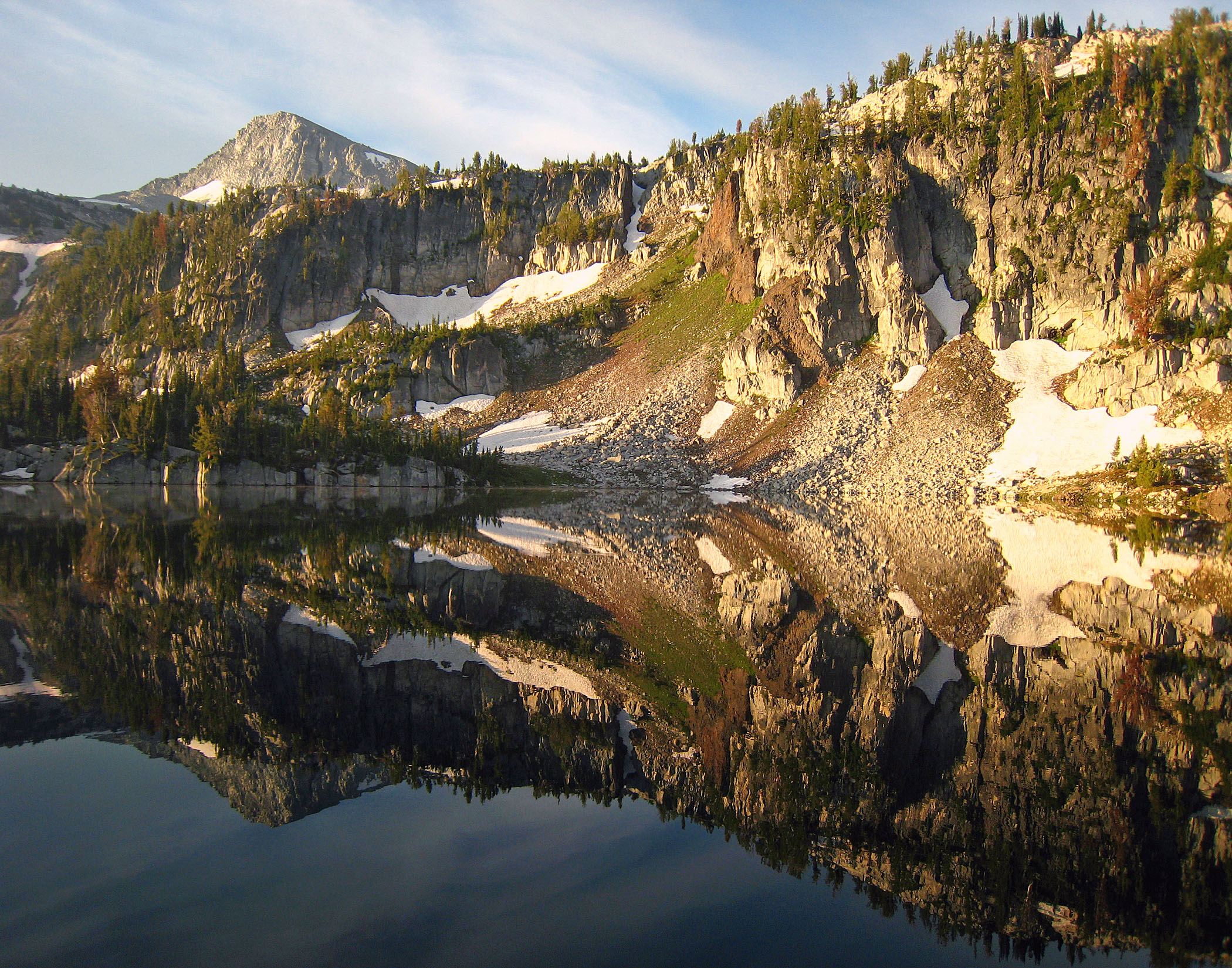
Eagle Cap reflects in Mirror Pond in the Lakes Basin Management Area of Eagle Cap Wilderness in northeast Oregon.
Summer reminds me of trips to the Wallowa Mountains in the Eagle Cap Wilderness. This shot was taken just after I bought my first DSLR camera, a Canon EOS 40D, but I really didn’t know what I was doing and did not have a wide-angle lens. So this photo of Eagle Cap reflected in Mirror Lake was taken with a Canon PowerShot SD 800 not longer after sunrise. It’s pretty clear how this lake got its name.
The McKenzie River cascades between Sahalie Falls and Koosah Falls.Sahalie Falls is a short walk from a parking lot.
No matter which side of the Cascades you live on, the McKenzie River offers a refreshing escape from a hot summer day. Accessed a few miles south of the junction of highways 20 and 126, there are numerous parking lots that make a perfect meeting spot between the southern Willamette Valley and Central Oregon.
The easiest, most popular and most impressive section of the 26.5-mile McKenzie River Trail is near its origin, where Sahalie Falls roars and Koosah Falls fans over basalt cliffs. Because of the volume of water, both falls can appear much taller than they actually are, though that doesn’t make them any less impressive. In between, the river rumbles over rocks and funnels through deep channels, where whitewater shares the spotlight with brilliant aqua and deep green.
A half-mile separates the waterfalls, and it can be traversed by trail or road. Although the footpath through old-growth forest is a little bumpy and has stairs in some areas, I can attest that even an 80-something grandmother can make the trek from one viewpoint to another. The west bank has more undulations and is frequented by mountain bikers, but it’s generally less crowded and offers of different perspective of each the falls. Numerous spurs off the main trail lead to the shore of the river, so children should be watched carefully.
The McKenzie River has an aqua color unless turned green by underwater moss.
The great thing about the McKenzie River Trail is that it gives you options. Hike or bike. A drive-by, an easy loop hike long enough to require a shuttle. Make it a pit stop or an entire weekend. A 2.5-mile loop from Sahalie Falls to Carmen Reservoir and back delivers the most postcards for minimal effort. There’s plenty to see no matter how much time you have, with several campgrounds along the trail for those who want to linger.
You can picnic along the river and watch dip their heads into the current for food, or head upstream about a half-mile to Clear Lake, the river’s origin. (Connect either via the trail or by driving.) A few miles south of the reservoir is Tamolitch Pool, also known as Blue Pool for its topaz hue. It sits below a dry fall that the McKenzie used to drop over. The river now flows underground, some through a lava bed and some diverted to a power plant, and reappears at this pool. Crazy people jump in, which, as you might expect, is dangerous.
For most, the powerful cascades and colorful river will be thrilling enough.
Columnar basalt at the base of Koosah Falls.Huge trees grow on the banks of the McKenzie River.There’s plenty of green both in the McKenzie River and along its banks.